


Published on Apr 02, 2024
A cruise missile is basically a small, pilotless airplane. Cruise missiles have an 8.5-foot (2.61-meter) wingspan, are powered by turbofan engines and can fly 500 to 1,000 miles (805 to 1,610 km) depending on the configuration. A cruise missile's job in life is to deliver a 1,000-pound (450-kg) high-explosive bomb to a precise location -- the target. The missile is destroyed when the bomb explodes.
Cruise missiles come in a number of variations and can be launched from submarines, destroyers or aircraft.
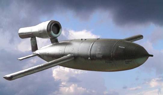
Cruise missiles generally consist of a guidance system , payload , and propulsion system , housed in an airframe with small wings and empennage for flight contro. Payloads usually consist of a conventional warhead or a nuclear warhead . Cruise missiles tend to be propelled by a jet engine , turbofan engines being preferred due to their greater efficiency at low altitude and sub-sonic speed.
An inertial guidance system is one that is designed to fly a predetermined path. The missile is controlled by self-contained automatic devices called accelerometers.Accelerometers are inertial devices that measure accelerations. In missile control, they measure the vertical, lateral, and longitudinal accelerations of the controlled missile (Ref. fig. 6) .Although there may not be contact between the launching site and the missile after launch, the missile is able to make corrections to its flight path with amazing precision. During flight, unpredictable outside forces, such as wind, work on the missile, causing changes in speed commands. These commands are transmitted to the missile by varying the characteristics of the missile tracking or guidance beam, or by the use of a separate radio uplink transmitter.
This data is taken by onboard computers and converted onto precise position of the missile.Lately, however, inertial systems have been combined with GPS (Global Positioning System) to navigate missiles more accurately. However, even with the best inertial systems available, missiles suffer from a phenomenon called drift. This is measured in distance (meters) per hour. For example, during the making of the Tomahawk Cruise missiles it was determined that even with the inertial navigation system, it would have a drift of 900 meters per hour. This essentially means that if the missile flew for one hour, it could miss the target by as much as 900 meters! Further, while ICBMs travel at sonic and supersonic speeds, smaller Cruise's speed was subsonic. So, the chances of missing the target are higher.
Early cruise missiles did not have the mapping satellites to draw information from, and there were plans to use a TERCOM-like system based on photographs rather than elevations. A series of photographs taken from surveillance aircraft were put into a carousel in the missile, which were selected at timed intervals and imaged using a television camera( Ref. fig 9). Another camera took pictures out of the bottom of the missile, imaged onto a similar display. A computer compared the two displays and attempted to line up areas of high contrast, similar to the contrast seekers used in the Maverick missile, and the offsets needed to align the two images could be decoded into a location and heading. However, this system proved to be very slow, and no such system was ever employed operationally, its role being taken up by TERCOM.
Terrain Contour Matching, or TERCOM, is a navigation system used primarily by cruise missiles. It uses a pre-recorded contour map of the terrain that is compared to measurements made during flight by an on-board radar altimeter. A TERCOM system considerably increases the accuracy of a missile compared to inertial navigation systems (INS). The increased accuracy allows a TERCOM-equipped missile to fly closer to obstacles and generally lower altitudes, making it harder to detect by ground radar.
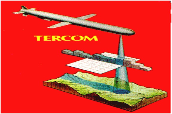
Figure 8
TERCOM navigation "maps" consist of a series of strips of land that the missile is expected to fly over, encoded as a series of altitudes (Ref.fig 8). Since a radar altimeter measures distances, height over the ground, and not an absolute altitude, the maps generally encode a series of changes in altitude, not the absolute altitude itself. Additionally, the strips of land on either side of the expected path are also stored. A series of such maps are produced, typically from data from radar mapping satellites. When flying over water, contour maps are replaced by magnetic field maps.
The missile's radar altimeter feeds measurements into a smaller buffer, which periodically "gates" the measurements over a period of time and averages them out to produce a single measurement. The series of such numbers held in the buffer produce a strip of measurements similar to those held in the maps. The two are compared to overlay the buffer's strip on the known map, and the positionig of the strip within the map produces a location and direction. The guidance system can then use this information to correct the flight path of the missile.
During the flight to the target the accuracy of the system has to be high enough only to avoid terrain features. This allows the maps to be relatively low resolution in these areas. Only the portion of the map for the terminal approach has to be higher resolution, and would normally be encoded at the highest resolutions available to the satellite mapping system.
TERCOM systems have the advantage of offering accuracy that is not based on the length of the flight; an inertial system slowly drifts after a "fix", and its accuracy is lower for longer distances. TERCOM systems receive constant fixes during the flight, and thus do not have any drift. Their absolute accuracy, however, is based on the accuracy of the radar mapping information, which is typically in the range of meters, and the ability of the processor to compare the altimeter data to the map quickly enough as the resolution increases. This generally limits first generation TERCOM systems to targets on the order of hundreds of meters, limiting them to the use of nuclear warheads. Use of conventional warheads requires further accuracy, which in turn demands additional terminal guidance systems.
One disadvantage of TERCOM systems is that the entire route has to be pre-planned, including its launch point. If the missile is launched from an unexpected location or flies too far off-course, it will never fly over the features included in the maps, and become lost. The INS system can help in this regard, allowing it to fly to the general area of the first patch, but gross errors simply cannot be corrected. This makes TERCOM based systems much less flexible than more modern systems like GPS, which can be set to attack any location from any location, and does not require any sort of pre-recorded information which means they can be targeted immediately prior to launch
| Are you interested in this topic.Then mail to us immediately to get the full report.
email :- contactv2@gmail.com |
